Polaris 20200303T211428 Parent Directory

Open page with static plots
Start timeEnd timeLast Latitude
& Longitude
Current
(1hr avg)
2020/03/03 21:28:21 GMT
2020/03/03 13:28:21 local
2020/03/03 21:57:20 GMT
2020/03/03 13:57:20 local
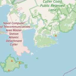
44.847267150854385
-67.58044433542567
-0.0 Amp
Downloads:
shore.nc
shore.mat
shore.kml
shore.kmz
shore.asc
shore.dir
shore.csv
shore.log
argos_24hr.kml
argos_week.kml, argos_month.kml
Elapsed time since start: 46540:19 Elapsed time since last valid data: 46539:50
MarkerMarker
Leaflet © OpenStreetMap contributors
Options for all plots below with a time axis:


Created with Highstock 6.1.3time (UTC)Depth (m)Vertical Plane21:3021:3521:4021:4521:5021:55-5-4-3-2-101ZoomAll1h3h6h12h1d3d1wFromMar 3, 2020ToMar 3, 2020Highcharts.com
Created with Highstock 6.1.3longitude (arcdeg)latitude (arcdeg)Navigation-67.580444-68-67.9-67.8-67.7-67.6-67.5-67.4-67.3-67.2-67.144.84726744.344.444.544.644.744.844.94545.145.245.345.4Highcharts.com
Created with Highstock 6.1.3time (UTC)battery_voltage (V)battery_voltage21:3021:3521:4021:4521:5021:5515.421875ZoomAll1h3h6h12h1d3d1wFromMar 3, 2020ToMar 3, 2020Highcharts.com
Created with Highstock 6.1.3time (UTC)battery_charge (Ah)battery_charge21:31:57.974249.191116ZoomAll1h3h6h12h1d3d1wFromMar 3, 2020ToMar 3, 2020Highcharts.com
Created with Highstock 6.1.3time (UTC)acoustic_contact_range (m)DUSBL_Hydroid21:3021:3521:4021:4521:5021:5500.250.50.7511.251.51.75ZoomAll1h3h6h12h1d3d1wFromMar 3, 2020ToMar 3, 2020Highcharts.com