Polaris 20220131T175324 Parent Directory

Open page with static plots
Start timeEnd timeLast Latitude
& Longitude
Current
(1hr avg)
2022/01/31 17:53:37 GMT
2022/01/31 09:53:37 local
2022/01/31 18:26:04 GMT
2022/01/31 10:26:04 local
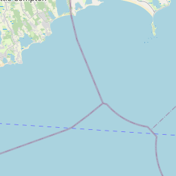
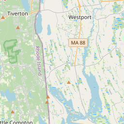
41.48227057100466
-70.88454665471355
-0.0 Amp
Downloads:
shore.nc
shore.mat
shore.kml
shore.kmz
shore.asc
shore.dir
shore.csv
shore.log
argos_24hr.kml
argos_week.kml, argos_month.kml
Elapsed time since start: 29676:45 Elapsed time since last valid data: 29676:13
MarkerMarker
Leaflet © OpenStreetMap contributors
Options for all plots below with a time axis:


Created with Highstock 6.1.3time (UTC)Depth (m)Vertical Plane17:5518:0018:0518:1018:1518:2018:25-5-4-3-2-101ZoomAll1h3h6h12h1d3d1wFromJan 31, 2022ToJan 31, 2022Highcharts.com
Created with Highstock 6.1.3longitude (arcdeg)latitude (arcdeg)Navigation-70.884-70.883-70.882-70.881-70.88-70.879-70.87841.482241.482341.482441.482541.482641.482741.482841.482941.48341.4821Highcharts.com
Created with Highstock 6.1.3time (UTC)average_current (mA)Platform18:0018:0518:1018:1518:2018:25350375400425450475500ZoomAll1h3h6h12h1d3d1wFromJan 31, 2022ToJan 31, 2022Highcharts.com
Created with Highstock 6.1.3time (UTC)time_fix (s)latitude_fix (arcdeg)longitude_fix (arcdeg)Other18:0018:0518:1018:1518:2018:251 643 651 5001 643 652 0001 643 652 5001 643 653 0001 643 653 5001 643 654 00041.48241.4822541.482541.4827541.483-70.885-70.8825-70.88-70.8775-70.875ZoomAll1h3h6h12h1d3d1wFromJan 31, 2022ToJan 31, 2022Highcharts.com
Created with Highstock 6.1.3time (UTC)battery_charge (Ah)battery_charge18:00:57.43977.717781ZoomAll1h3h6h12h1d3d1wFromJan 31, 2022ToJan 31, 2022Highcharts.com