Polaris 20220420T151609 Parent Directory

Open page with static plots
Start timeEnd timeLast Latitude
& Longitude
Current
(1hr avg)
2022/04/20 15:16:22 GMT
2022/04/20 08:16:22 local
2022/04/20 16:16:07 GMT
2022/04/20 09:16:07 local
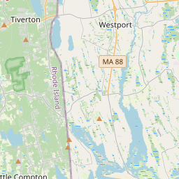
41.51118217645947
-70.7872658678556
-0.0 Amp
Downloads:
shore.nc
shore.mat
shore.kml
shore.kmz
shore.asc
shore.dir
shore.csv
shore.log
argos_24hr.kml
argos_week.kml, argos_month.kml
Elapsed time since start: 27783:10 Elapsed time since last valid data: 27782:10
MarkerMarkerMarkerMarker
Leaflet © OpenStreetMap contributors
Options for all plots below with a time axis:


Created with Highstock 6.1.3time (UTC)Depth (m)Vertical Plane15:2015:3015:4015:5016:0016:10-5-4-3-2-101ZoomAll1h3h6h12h1d3d1wFromApr 20, 2022ToApr 20, 2022Highcharts.com
Created with Highstock 6.1.3longitude (arcdeg)latitude (arcdeg)Navigation-70.793-70.792-70.791-70.79-70.789-70.78841.51141.511241.511441.511641.511841.51241.512241.512441.512641.512841.5112541.511541.5117541.5122541.512541.5127541.513Highcharts.com
Created with Highstock 6.1.3time (UTC)time_fix (s)latitude_fix (arcdeg)longitude_fix (arcdeg)Other15:2015:2515:3015:3515:4015:4515:5015:5516:0016:051 650 467k1 650 468k1 650 469k1 650 470k1 650 471k41.51141.511541.51241.512541.513-70.795-70.7925-70.79-70.7875-70.785ZoomAll1h3h6h12h1d3d1wFromApr 20, 2022ToApr 20, 2022Highcharts.com
Created with Highstock 6.1.3time (UTC)battery_charge (Ah)battery_charge15:23:45.055231.773331ZoomAll1h3h6h12h1d3d1wFromApr 20, 2022ToApr 20, 2022Highcharts.com
Created with Highstock 6.1.3time (UTC)fix_residual_percent_distance_traveled (%)fix_residual_percent_distance_traveled16:06:49.56310.004044ZoomAll1h3h6h12h1d3d1wFromApr 20, 2022ToApr 20, 2022Highcharts.com