Polaris 20250606T170254 Parent Directory

Open page with static plots
Start timeEnd timeLast Latitude
& Longitude
Current
(1hr avg)
2025/06/06 17:03:11 GMT
2025/06/06 10:03:11 local
2025/06/06 17:23:29 GMT
2025/06/06 10:23:29 local
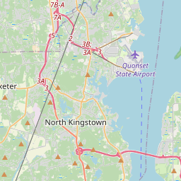
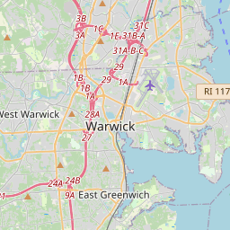
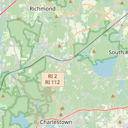
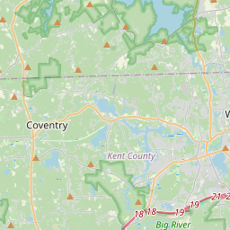
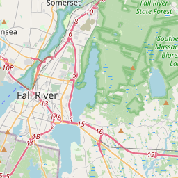
41.508174499907035
-71.33922216584355
-0.0 Amp
Downloads:
shore.nc
shore.mat
shore.kml
shore.kmz
shore.asc
shore.dir
shore.csv
shore.log
argos_24hr.kml
argos_week.kml, argos_month.kml
Elapsed time since start: 433:19 Elapsed time since last valid data: 432:59
MarkerMarker
Leaflet © OpenStreetMap contributors
Options for all plots below with a time axis:


Created with Highstock 6.1.3time (UTC)Depth (m)Vertical Plane17:0417:0617:0817:1017:1217:1417:1617:1817:2017:22-5-4-3-2-101ZoomAll1h3h6h12h1d3d1wFromJun 6, 2025ToJun 6, 2025Highcharts.com
Created with Highstock 6.1.3longitude (arcdeg)latitude (arcdeg)Navigation-71.3399-71.3398-71.3397-71.3396-71.3395-71.3394-71.339341.50802541.5080541.50807541.508141.50812541.5081541.50817541.508241.50822541.50825Highcharts.com
Created with Highstock 6.1.3time (UTC)time_fix (s)latitude_fix (arcdeg)longitude_fix (arcdeg)Other17:0617:0817:1017:1217:1417:1617:1817:201 749 229 0001 749 229 5001 749 230 0001 749 230 5001 749 231 00041.50841.508141.508241.5083-71.34025-71.34-71.33975-71.3395-71.33925-71.339ZoomAll1h3h6h12h1d3d1wFromJun 6, 2025ToJun 6, 2025Highcharts.com
Created with Highstock 6.1.3time (UTC)battery_charge (Ah)battery_charge17:10:32.208211.746674ZoomAll1h3h6h12h1d3d1wFromJun 6, 2025ToJun 6, 2025Highcharts.com
Created with Highstock 6.1.3time (UTC)height_above_sea_floor (m)height_above_sea_floor17:21:19.566163.476562ZoomAll1h3h6h12h1d3d1wFromJun 6, 2025ToJun 6, 2025Highcharts.com