Polaris 20200506T212506 Parent Directory

Open page with static plots
Start timeEnd timeLast Latitude
& Longitude
Current
(1hr avg)
2020/05/06 21:25:18 GMT
2020/05/06 14:25:18 local
2020/05/06 22:12:35 GMT
2020/05/06 15:12:35 local
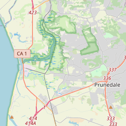
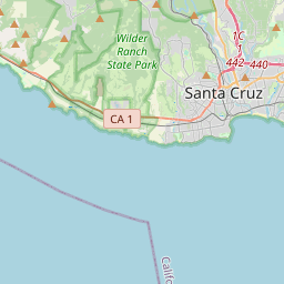
36.80378099962232
-121.8231479999951
-0.0 Amp
Downloads:
shore.nc
shore.mat
shore.kml
shore.kmz
shore.asc
shore.dir
shore.csv
shore.log
argos_24hr.kml
argos_week.kml, argos_month.kml
Elapsed time since start: 44957:33 Elapsed time since last valid data: 44956:46
MarkerMarker
Leaflet © OpenStreetMap contributors
Options for all plots below with a time axis:


Created with Highstock 6.1.3time (UTC)Depth (m)Vertical Plane21:3021:3521:4021:4521:5021:5522:0022:0522:10-5-4-3-2-101ZoomAll1h3h6h12h1d3d1wFromMay 6, 2020ToMay 6, 2020Highcharts.com
Created with Highstock 6.1.3longitude (arcdeg)latitude (arcdeg)Navigation-121.823148-122.3-122.2-122.1-122-121.9-121.8-121.7-121.6-121.5-121.436.80378136.336.436.536.636.736.836.93737.137.237.337.4Highcharts.com
Created with Highstock 6.1.3time (UTC)time_fix (s)latitude_fix (arcdeg)longitude_fix (arcdeg)Other21:26:44.9911 588 800 262.05692436.803781-121.823148ZoomAll1h3h6h12h1d3d1wFromMay 6, 2020ToMay 6, 2020Highcharts.com
Created with Highstock 6.1.3time (UTC)battery_voltage (V)battery_voltage21:3021:3521:4021:4521:5021:5522:0022:0522:1016.64516.6516.65516.6616.66516.6716.67516.6816.68516.6916.695ZoomAll1h3h6h12h1d3d1wFromMay 6, 2020ToMay 6, 2020Highcharts.com
Created with Highstock 6.1.3time (UTC)battery_charge (Ah)battery_charge21:32:28.433355.582214ZoomAll1h3h6h12h1d3d1wFromMay 6, 2020ToMay 6, 2020Highcharts.com
Created with Highstock 6.1.3time (UTC)Altitude (m)RDI_PathfinderUp21:3021:3521:4021:4521:5021:5522:0022:0522:100ZoomAll1h3h6h12h1d3d1wFromMay 6, 2020ToMay 6, 2020Highcharts.com